7Semi L89HA Breakout: Unleash the Power of Multi-GNSS for Precision Positioning
The 7Semi L89HA Breakout empowers your projects with robust and accurate positioning data, leveraging the power of multi-GNSS (Global Navigation Satellite System) technology. This compact module integrates Quectel's IRNSS-enabled GNSS module, boasting dual embedded antennas for seamless operation on both L1 and L5 bands.
Uncompromised Performance:
- Extensive GNSS Compatibility: Gain access to a comprehensive set of global navigation satellite systems, including GPS, IRNSS, GLONASS, BeiDou, Galileo, and QZSS, ensuring exceptional positioning coverage worldwide.
- Rapid Fix and Reliable Navigation: Experience swift time-to-first-fix and dependable navigation capabilities with support for concurrent reception of up to three GNSS constellations. This translates to consistent performance even in environments with limited satellite visibility, such as urban canyons or dense foliage.
- Concurrent Multi-Constellation Reception: The L89HA Breakout can receive signals from up to three GNSS constellations simultaneously. This synergizes data for superior positioning accuracy, especially in challenging environments with limited satellite visibility, such as urban canyons or dense foliage.
Simplified Integration:
- Low-Power Operation: The 7Semi L89HA Breakout operates on a low-power 3.3V supply, minimizing power consumption and simplifying integration into existing battery-powered systems.
- Flexible Communication Interfaces: I2C and UART interfaces provide seamless communication with a wide range of microcontrollers and processors, ensuring compatibility with your development platform of choice.
Compact Design for Space-Constrained Applications:
- Embedded Patch and Chip Antennas: Eliminate the need for bulky external antennas. The integrated patch and chip antennas minimize the module's footprint, making it ideal for space-constrained applications like drones, wearables, and Internet of Things (IoT) devices.
- Simplified System Design: The L89HA Breakout operates on a low-power 3.3V supply, minimizing power consumption concerns. It also features I2C and UART communication interfaces, offering flexibility and seamless integration with a vast array of microcontrollers and processors used in various applications.
Advanced Functionality:
- Enhanced Sensitivity and Accuracy: The 7Semi L89HA Breakout boasts an advanced RF design coupled with sophisticated signal processing algorithms. This combination delivers exceptional sensitivity and precise positioning data, even in challenging environments.
Applications across Diverse Industries:
- Navigation and Tracking: Monitor the location and movement of assets or personnel in real-time, ideal for fleet management, logistics, and personal safety applications.
- Precise Timing: Maintain accurate time synchronization across critical operations, ensuring smooth functioning in applications like financial transactions and communication networks.
- Geofencing: Establish virtual boundaries to trigger actions or send alerts when a designated area is entered or exited. This functionality proves valuable in applications like livestock monitoring or restricted zone control.
- Drone and Robotics: Enable unmanned aerial vehicles (UAVs) and autonomous robots with precise positioning and navigation capabilities, facilitating tasks like aerial photography, search and rescue operations, and automated inspection routines.
- Internet of Things (IoT): Integrate location-based functionalities into a vast array of IoT devices, creating a network of intelligent devices with real-time location awareness. This opens doors for innovative applications in smart agriculture, asset tracking, and connected cities.
The 7Semi L89HA Breakout offers a compelling solution for projects demanding high-precision positioning and reliable navigation. Its compact form factor, versatile communication interfaces, and exceptional performance make it a perfect choice for developers working on a wide range of GNSS-based applications.
Key Features
- 3.3V power supply
- I2C / UART interface
- Support IRNSS L5 band
- Embedded patch antenna and chip antenna
- Multi-GNSS engines for GPS, IRNSS, GLONASS, BeiDou, Galileo and QZSS
- Support DGPS, SBAS (WAAS/EGNOS/MSAS/GAGAN)
- Integrated LNAs for better sensitivity
- Great anti-jamming performance due to multi-tone active interference canceller
Note: Battery is not included in the package
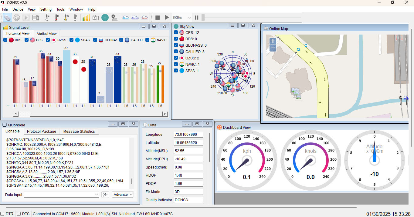
How to Enable IRNSS (Indian Regional Navigation Satellite System (IRNSS) : NavIC)
Follow the steps given below-
- Connect USB to serial converter to L89 and Open Serial port into Qnavigator.
- To enable IRNSS please use the following AT command .
- Use External Active antenna with Open roof/sky.
- L89 AT command manual can be downloaded from the resources link.
Resources
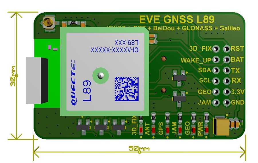
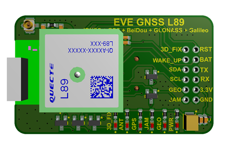
L89 Breakout Dimensions
L89 Breakout Arduino Connection

Arduino Code for GPS Read
#include <SoftwareSerial.h> // Include the SoftwareSerial library
#define ARDUINO_GPS_RX 9 // Arduino RX pin connected to GPS TX
#define ARDUINO_GPS_TX 8 // Arduino TX pin connected to GPS RX
#define GPS_BAUD_RATE 9600 // The GPS Shield module defaults to 9600 baud
// Create a SoftwareSerial object called gps:
SoftwareSerial gpsPort(ARDUINO_GPS_TX, ARDUINO_GPS_RX);
// This is the hardware serial port on pins 0/1.
#define SerialMonitor Serial
void setup()
{
gpsPort.begin(GPS_BAUD_RATE);
SerialMonitor.begin(9600);
}
void loop()
{
if (gpsPort.available()) // If GPS data is available
SerialMonitor.write(gpsPort.read()); // Read it and print to SerialMonitor
if (SerialMonitor.available()) // If SerialMonitor data is available
gpsPort.write(SerialMonitor.read()); // Read it and send to GPS
}
L89 Breakout Vs L86 Breakout
| Parameters |
L89 Breakout |
L86 Breakout |
| Image |
 |
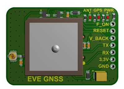 |
| Receiving Bands |
GPS L1/Galileo E1 C/A: 1575.42 MHz |
GPS L1 Band Receiver (1575.42MHz) |
| |
GLONASS L1 C/A: 1602.5625 MHz |
GLONASS L1 Band Receiver (1601.71MHz): |
| |
IRNSS L5 C/A: 1176.45 MHz |
|
| |
BD2 B1 C/A: 1561.098 MHz |
|
| SBAS |
WAAS, EGNOS, MSAS, GAGAN |
WAAS, EGNOS, MSAS, GAGAN |
| Horizontal Position Accuracy |
Autonomous: < 1.8 m CEP |
Autonomous: <2.5m CEP |
| Velocity Accuracy |
Without Aid: < 0.1 m/s |
Without Aid: <0.1m/s |
| Acceleration Accuracy |
Without Aid: < 0.1 m/s² |
|
| Timing Accuracy |
1PPS: 3.9 ns |
1PPS Out: 10ns |
| Reacquisition Time |
< 1.5 s |
<1s |
| Sensitivity |
Acquisition: -147 dBm
Tracking: -163 dBm
Reacquisition: -156 dBm |
Acquisition: -149dBm
Tracking: -167dBm
Reacquisition: -161dBm |
| Dynamic Performance |
Maximum Altitude: Max. 18000 m
Maximum Velocity: Max. 515 m/s
Maximum Acceleration: 4G |
Maximum Altitude: Max. 18000m
Maximum Velocity: Max. 515m/s
Maximum Acceleration: 4G |
| Link |
L89 Breakout |
L86 Breakout |
A GPS (Global Positioning System) and GNSS (Global Navigation Satellite System) breakout is a type of breakout board that allows a microcontroller or other electronic system to easily receive and interpret satellite signals for location and timing purposes. The board typically features a small circuit board with a set of pins that can be easily connected to a microcontroller or other device. The board also includes a GPS or GNSS module that receives signals from multiple satellites and calculates the precise location, speed, and time of the connected device. GPS and GNSS breakouts are commonly used in a wide range of applications, including navigation systems, drones, and other location-based systems. The GPS and GNSS breakout is an essential component in many electronic systems that require precise location and timing information.


 with Patch Antenna")


